Appendix B
Forecasting Weather in the Mountains
The Air Force provides the bulk of the weather support required by the Army;
however, reports from other branches of the military service, our own National
Weather Bureau, or a foreign country’s weather service can also aid in developing
accurate forecasts (see FM 2-33.2). Weather at
different elevations and areas, even within the same general region, may differ
significantly due to variations in cloud height, temperature, winds, and barometric
pressure. Therefore, general reports and forecasts must be used in conjunction
with the locally observed weather conditions to produce reliable weather forecasts
for a particular mountain area of operations.
INDICATORS OF CHANGING WEATHER
MEASURABLE INDICATORS
Figure B-1. Measurable Weather Indicators
- Barometric Pressure
- Wind Velocity
- Wind Direction
- Temperature
- Moisture Content of the Air
|
|
B-1. In the mountains, a portable aneroid barometer, thermometer, wind meter, and hygrometer are useful to obtain measurements that will assist in forecasting the weather. Marked or abnormal changes within a 12-hour period in the indicators listed in Figure B-1 may suggest a potential change in the weather.
CLOUDS
B-2. Clouds are good indicators of approaching weather conditions. By reading cloud shapes and patterns, observers can forecast weather even without additional equipment.
B-3. Shape and height are used to identify clouds. Shape provides information about the stability of the atmosphere, and height above ground level provides an indication of the distance of an approaching storm. Taken together, both indicate the likelihood of precipitation (see Figure B-2). The heights shown in the figure are an estimate and may vary, based on geographical location.
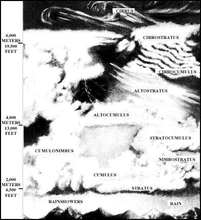
Figure B-2. Types of Clouds
Clouds by Shape
B-4. Clouds may be classified by shape as cumulus or stratus.
- Cumulus clouds are often called "puffy" clouds, looking like tufts of cotton. Their thickness (bottom to top) is usually equal to or greater than their width. Cumulus clouds are primarily composed of water droplets that cause them to have sharp, distinct edges. These clouds usually indicate instability at the altitude of the atmosphere where they are found. The stormy weather associated with cumulus clouds is usually violent with heavy rains or snow and strong, gusty winds. Precipitating cumulus clouds are called cumulonimbus.
- Stratus clouds are layered, often appearing flattened, with greater horizontal than vertical dimensions. They usually indicate a stable atmosphere, but can indicate the approach of a storm. Stormy weather associated with stratus clouds usually does not normally include violent winds, and precipitation is usually light but steady, lasting up to 36 hours. Lightning is rarely associated with stratus clouds, however, sleet may occur. Fog is also associated with the appearance of stratus clouds. Precipitating stratus clouds are called nimbostratus, and clouds that cannot be determined as stratus or cumulus are referred to as stratocumulus. These latter types may be evolving from one type to another, indicating a change in atmospheric stability.
Clouds by Height
B-5. Clouds are also classified by the height of their base above ground level into three categories – low, middle, and high.
- Low clouds, below 2,000 meters (6,500 feet), are either cumulus or stratus, or their precipitating counterparts. Low clouds may be identified by their height above nearby surrounding relief of known elevation. Most precipitation originates from low clouds because rain and snow from higher clouds usually evaporates before reaching the ground. As such, low clouds usually indicate precipitation, especially if they are more than 1,000 meters (3,000 feet) thick (clouds that appear dark at the base usually are at least that thick).
- Middle clouds, between 2,000 and 6,000 meters (6,500 and 19,500 feet) above ground, have a prefix of "alto", and are called either altostratus or altocumulus. Middle clouds appear less distinct than low clouds because of their height. Warm "alto" clouds have sharper edges and are composed mainly of water droplets. Colder clouds, composed mainly of ice crystals, have distinct edges that grade gradually into the surrounding sky. Middle clouds indicate potential storms, though usually hours away. Altocumulus clouds that are scattered in a blue sky are called "fair weather" cumulus and suggest the arrival of high pressure and clear skies. Lowering altostratus clouds with winds from the south indicate warm front conditions, decreasing air pressure, and an approaching storm system within 12 to 24 hours.
- High clouds, higher than 6,000 meters (19,500 feet), are cirrus, cirrostratus, and cirrocumulus. They are usually frozen clouds with a fibrous structure and blurred outlines. The sky is often covered with a thin veil of cirrus that partly obscures the sun or, at night, produces a ring of light around the moon. The arrival of cirrus indicates moisture aloft and the approach of a storm system. Precipitation is often 24 to 36 hours away. As the storm approaches, the cirrus thickens and lowers becoming altostratus and eventually stratus. Temperatures warm, humidity rises, and winds approach from the south or southeast.
Other Clouds
B-6. Some clouds indicate serious weather ahead.
- Towering cumulus clouds have bases below 2,000 meters (6,500 feet) and tops often over 6,000 meters (19,500 feet). They are the most dangerous of all types and usually do not occur when temperatures at the surface are below 32-degrees Fahrenheit. They indicate extreme instability in the atmosphere, with rapidly rising air currents caused by solar heating of the surface or air rising over a mountain barrier. Mature towering cumulus clouds often exhibit frozen stratus clouds at their tops, producing an "anvil head" appearance. Towering cumulus clouds may be local in nature, or they may be associated with the cold front of an approaching storm. The latter appears as an approaching line of thunderstorms or towering cumulus clouds. Towering cumulus clouds usually produce high, gusty winds, lightning, heavy showers, and occasionally hail and tornadoes (although tornadoes are rare in mountainous terrain). Such thunderstorms are usually short-lived and bring clear weather.
- Cloud caps often form above pinnacle and peaks, and usually indicate higher winds aloft. Cloud caps with a lens shape (similar to a "flying saucer") are called lenticular and indicate very high winds (over 40 knots). Cloud caps should always be watched for changes. If they grow and descend, bad weather can be expected.
APPLYING THE INDICATORS
B-7. Weather forecasts are simply educated estimations or deductions based on general scientific weather principles and meteorological evidence. Forecasts based on past results may or may not be accurate. However, even limited experience in a particular mountainous region and season may provide local indications of impending weather patterns and increased accuracy. Native weather lore, although sometimes greatly colored and surrounded in mystique, should not be discounted when developing forecasts, as it is normally based on the local inhabitants’ long-term experience in the region.
BAD WEATHER
B-8. Signs of approaching bad weather (within 24 to 48 hours) may include—
- A gradual lowering of the clouds. This may be the arrival or formation of new lower strata of clouds. It can also indicate the formation of a thunderhead.
- An increasing halo around the sun or the moon.
- An increase in humidity and temperature.
- Cirrus clouds.
- A decrease in barometric pressure (registered as a gain in elevation on an altimeter).
STORM SYSTEMS
B-9. The approach of a storm system is indicated when—
- A thin veil of cirrus clouds spreads over the sky, thickening and lowering until altostratus clouds are formed. The same trend is shown at night when a halo forms around the moon and then darkens until only the glow of the moon is visible. When there is no moon, cirrus clouds only dim the stars, but altostratus clouds completely hide them.
- Low clouds, which have been persistent on lower slopes, begin to rise at the time upper clouds appear.
- Various layers of clouds move in at different heights and become abundant.
- Lenticular clouds accompanying strong winds lose their streamlined shape, and other cloud types appear in increasing amounts.
- A change in the direction of the wind is accompanied by a rapid rise in temperature not caused by solar radiation. This may also indicate a warm, damp period.
- A light green haze is observed shortly after sunrise in mountain regions above the timberline.
THUNDERSTORMS
B-10. Indications of local thunderstorms or squally weather are—
- An increase in size and rapid thickening of scattered cumulus clouds during the afternoon.
- The approach of a line of large cumulus or cumulonimbus clouds with an "advance guard" of altocumulus clouds. At night, increasing lightning windward of the prevailing wind gives the same warning.
- Massive cumulus clouds hanging over a ridge or summit (day or night).
STRONG WINDS
B-11. Indications of approaching strong winds may be—
- Plumes of blowing snow from the crests of ridges and peaks or ragged shreds of cloud moving rapidly.
- Persistent lenticular clouds, a band of clouds over high peaks and ridges, or downwind from them.
- A turbulent and ragged banner cloud that hangs to the lee of a peak.
PRECIPITATION
B-12. When there is precipitation and the sky cannot be seen—
- Small snowflakes or ice crystals indicate that the clouds above are thin, and fair weather exists at high elevations.
- A steady fall of snowflakes or raindrops indicates that the precipitation has begun at high levels, and bad weather is likely to be encountered on ridges and peaks.
FAIR WEATHER
B-13. Continued fair weather may be associated with—
- A cloudless sky and shallow fog, or layers of haze at valley bottoms in early morning.
- A cloudless sky that is blue down to the horizon or down to where a haze layer forms a secondary horizon.
- Conditions under which small cumulus clouds appearing before noon do not increase, but instead decrease or vanish during the day.
- Clear skies except for a low cloud deck that does not rise or thicken during the day.
B-14. Signs of approaching fair weather include—
- A gradual rising and diminishing of clouds.
- A decreasing halo around the sun or moon.
- Dew on the ground in the morning.
- Small snowflakes, ice crystals, or drizzle, which indicate that the clouds are thin and fair weather may exist at higher elevations.
- An increase in barometric pressure (registered as a loss in elevation on an altimeter).


